Views from the newly designated “James Cook Heritage Trail”
Commemorations (2017-2018)
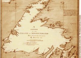
Cabox Geopark Commemorates Cook Newfoundland Chart
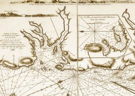
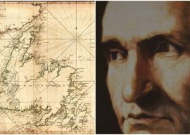
On October 26, Cabox Geopark in Western Newfoundland commemorated the 250th Anniversary of James Cook's 'Chart of the West Coast of Newfoundland'. Considered by many to be Cook's finest map, the chart was published a year after his last survey in Eastern Canada, after being selected to command a voyage to the Pacific Ocean to witness the transit of Venus and search for the fabled southern continent.
read moreHockey Tournament in Honour of James Cook
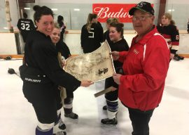
The 20th Anniversary Captain Cook Hockey Tournament wrapped up March 4, 2018 at the Civic Centre in Corner Brook, Newfoundland. Held during the 250th anniversary of Cook preparing his 'Chart of the West Coast of Newfoundland', the 24 teams vied for bragging rights and commemorative James Cook 250 maps of the island of Newfoundland.
read moreInternational Trail Commemorates Cook Survey
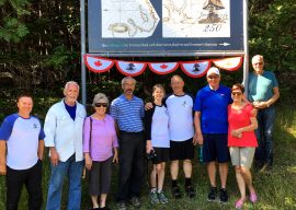
During summer 2017, the International Appalachian Trail Newfoundland & Labrador in conjunction with Cabox Aspiring Geopark commemorated the 250th Anniversary of British navigator, surveyor, cartographer and explorer James Cook's survey of Western Newfoundland, his fifth and final year of Newfoundland surveys and tenth and final year in Eastern Canada.
read moreFamous surveyor James Cook also a brewmaster
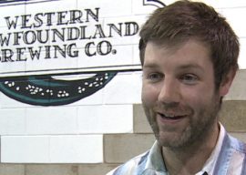
When James Cook surveyed the coasts of Newfoundland in the 1700s, his crew would go ashore and make spruce beer. The drink not only quenched the sailors' thirst, spruce beer was credited in part for Cook's high success rate at preventing scurvy. Two hundred and fifty years after Cook put Newfoundland on the map, the Western Newfoundland Brewing Company is making a spruce beer of its own.
read moreNewfoundland’s James Cook 250 makes NTV Evening News Hour
He’s regarded as one of history’s greatest navigators, but events to mark the 250th anniversary of Capt. James Cook’s time mapping the coast of Newfoundland have gone largely unnoticed. A group in Corner Brook is trying to change that. Here's that story, as seen on the Tuesday edition of the NTV Evening News Hour.
read morePlans in place to raise awareness of Capt. James Cook’s important mapping work in Bay of Islands
James Cook spent five years mapping out much of the coastline of Newfoundland and parts of Labrador. This year marks the 250th anniversary of his last year doing his cartographic work, with that final year of 1767 spent surveying and charting the western Newfoundland coastline. This summer, events will mark Cook’s final year in the Newfoundland and Labrador area.
read moreThe GPS of its time: Surveyor James Cook remembered 250 years after mapping Newfoundland
A world renowned explorer who literally put Newfoundland and Labrador on the map is being recognized for his work 250 years later. James Cook surveyed most of the province from 1763-1767, charting areas unknown to the British at the time. James Cook 250 celebrations tie in with Canada 150 and the Tall Ships Regatta that’s coming to Corner Brook and the Northern Peninsula the end of July
read moreJames Cook 250 Exhibits
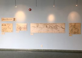
Throughout summer 2017, new James Cook 250 Exhibits were held at key locations in Western Newfoundland, from Benoit's Cove and Gillams in the Bay of Islands to the Discovery Center at Woody Point in Gros Morne National Park.
read moreCook Exhibit at Corner Brook Museum
The Corner Brook Museum and Archives will celebrate Cook 250 through its permanent exhibit of 'Cook and Canada' developed in partnership with the Captain Cook Memorial Museum in Whitby, Yorkshire, England. The exhibit includes a copy of Cook's map of the southern half of the West Coast of Newfoundland
read moreJames Cook Heritage Trail

On July 26, 2017, a 1.6 km scenic walking trail to Tortoise Head in Blow Me Down Provincial Park was designated the "James Cook Heritage Trail". Joining Cabox Aspiring Geopark and Outer Bay of Islands Enhancement Committee members were special guests David Startzell, long-time Executive Director of the Appalachian Trail Conservancy, and his wife Judy, former Editor of magazine A.T. Journeys.
read moreCape “Blow Me Down” Trail
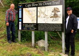
On Canada Day 2017, the OBIEC / IATNL 'Copper Mine To Cape Trail' in York Harbour was designated the 'Cape Blow Me Down Trail' in honour of James Cook and his 1767 survey of the Bay of Islands. A number of storyboards at the trailhead and along the route to the Cape will tell the story of Cook in the bay.
read moreHumber Valley Trail Rebranded
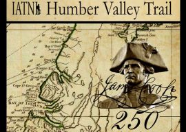
The scenic Humber Valley Trail east of the city of Corner Brook, Newfoundland has been rebranded with a James Cook theme. Cook explored the river in September 1767, penetrating approximately 40 kilometers up the river into Deer Lake. It was the first serious attempt to map the inland topography of Newfoundland.
read more4th General Meeting of Aspiring Geopark
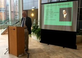
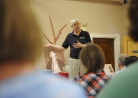
On November 28, 2016, the 4th general meeting of Cabox Aspiring Geopark was held at the Atrium of Grenfell Campus, Memorial University of Newfoundland in Corner Brook. In addition to updates on the past year's developments and a preview of next year's Cook 250 commemoration, Grenfell History Professor Olaf Janzen gave a presentation on James Cook in Newfoundland.
read more7th International Geopark Conference
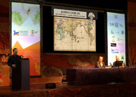
On September 27-30, 2016, IAT / Cabox Aspiring Geopark Chairperson Paul Wylezol attended the 7th International Conference on UNESCO Global Geoparks at Torquay, England, where he learned more about the UNESCO Global Geopark programme and gave a presentation on the 250th Anniversary of James Cook's completing his surveys of Eastern Canada.
read moreJames Cook and the North Atlantic Drift
A fascinating talk at James Cook Birthplace Museum on Saturday celebrated Marton born explorer, James Cook’s early naval career in Eastern Canada but also offered a maple leaf to bring both sides of the Atlantic together in celebration of the great man’s achievements.
read moreIAT Presents at England’s Cook Museums
On September 16 & 17, 2016, IAT / Cabox Aspiring Geopark Chairperson Paul Wylezol was in Yorkshire, England visiting the Captain Cook Memorial Museum in Whitby and Captain Cook Birthplace Museum in Marton where he gave a presentation on the 250th Anniversary of James Cook completing his surveys of Eastern Canada.
read more