By Helen Pitt,
As celebrations kick off in Plymouth, England this weekend to mark 250 years since Captain James Cook set sail for Australia in 1768, local amateur maritime historians are pushing for the establishment of a Cook Heritage Trail along the east coast of Australia.
While the federal government announced plans to mark the Cook legacy with a $50 million park at Kurnell in Botany Bay by 2020, including a $3 million commemorative statue of Captain James Cook, amateur historians are calling to redraw our east coast map and rename land features according to Cook’s log.
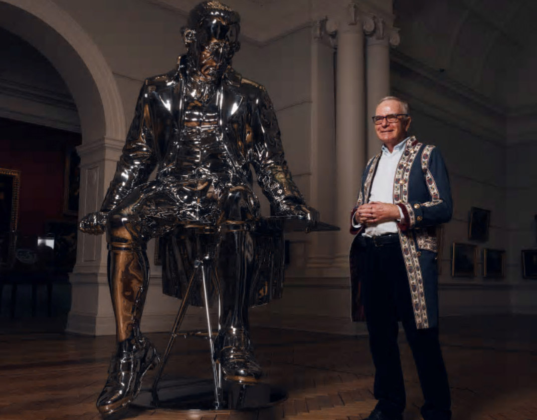
 Captain Cook enthusiast Donald Heussler, pictured next to a sculpture of Captain Cook entitled The English Channel by New Zealand artist Michael Parekowhai at the Art Gallery of NSW. Photo: James Brickwood
The proposed heritage trail – which would stretch along the coast from Point Hicks (near Cann River), Victoria, to Point Danger on the Queensland border – is part of the Restoring Cook’s Legacy 2020 project and would include commemorative interpretative plaques at, or near, all of Cook’s 28 named features. The Heritage Trail idea is a joint initiative of Australia on the Map and the history and heritage division of the Australasian Hydrographic Society.
Trevor Lipscombe, one of the amateur historians involved, said many land features or landmarks that Cook named are shown in the wrong places on today’s maps. These include Broken Bay, Point Danger, Cape St George and Long Nose in Jervis Bay and Red Point, near Mt Kembla, in Wollongong.
“Recent research has revealed that of the 28 land features Cook named on the coasts of Victoria and NSW no less that nine [nearly a third] are either shown in the wrong place on today’s maps or [in two cases] are shown in the right place but widely believed to be elsewhere,” said Mr Lipscombe.
“I am of the opinion that the Narrabeen lagoon is what Cook named as Broken Bay and in Victoria there were a comedy of errors in naming Cook landmarks – we are going to put political pressure on in Victoria and hopefully get a lot of renames through the Geographic Names Board there,” he said.
“Cook was always a stickler for accuracy and the 250th anniversary of his voyage provides an opportunity to correct these errors,” he said.
The misnamings and misplacings occurred, said Mr Lipscombe, because Cook was a sea-based hydrographer, rather than the land-based hydrographers who followed in the 1800s.
Incorrectly named and located geographic points sighted by Captain Cook:
- Point Hicks (East Gippsland) VIC
- Ram Head (renamed Rame Head in Croajingolong National Park VIC
- Cape Howe Croajingolong National Park VIC
- Cape Dromedary southern NSW
- Cape St George, Jervis Bay NSW
- Long Nose, Jervis Bay NSW
- Red Point, (near Mt Kembla, NSW – what Cook saw was near Ulladulla)
- Broken Bay NSW (not the entry to Hawkesbury River, scholars believe what Cook saw was the entry to Narrabeen Lake.
- Black Head, Port Stephens NSW
- Point Danger (border of NSW/Queensland)
“Cook for me, like many young men, has always been a heroic figure like Lawrence of Arabia or John Monash and it is time to restore his legacy,” Mr Lipscombe said.
When Captain James Cook left on his epic voyage for Australia aboard the Endeavour on August 25, 1768, the last land mass he glimpsed on the starboard side as he sailed out of the English Channel was Ram Head in Cornwall.
Twenty months later, when he arrived on the Australian coast, the first land feature he named was Ram Head, Victoria (currently Little Rame Head now misplaced and misnamed, Mr Lipscombe said, in Croajingolong National Park). He conceded there will be difficulties of renaming the incorrectly placed Cook landmarks but the group is also aiming to get some of these heritage listed. “They are an important and neglected part of Australia’s heritage.”
Mal Nicholson, president of local chapter of the Captain Cook Society, said the heritage trail is but one of the many recent discoveries which were presented at its meeting this week. Another was by amateur historian Donald Heussler whose scientific research found Cook’s marine telescopes were much more powerful than previously thought. On January 12, 1770, Joseph Banks reported in his journal what he thought were “flocks of sheep” on Mt Taranaki, but were more likely native New Zealand alpine plants (Raoulia genus), proving the power of their navigation equipment.
“This is the first absolute proof of Cook’s ability to see every detail of the new lands from his ship which was usually 10-25 kilometres at sea,” Mr Heussler said.
The Discovery Channel/Foxtel will broadcast a multi-part series Uncharted on Cook’s three epic Pacific voyages, 1768-1779, to be narrated by New Zealand actor and Cook aficionado Sam Neill.
A new Cook sculpture at the Art Gallery of New South Wales by Maori artist Michael Parekowhai, which is a replica of one unveiled this year on the Auckland waterfront, was recently bequeathed by philanthropist Peter Weiss.
The statue, which has been a huge hit with school students because many liken it to the shiny robot in the Terminator films, provokes a more contemporary, reflective view of the explorer, said Justin Paton, the gallery’s head curator of international art. He said the piece, which is “a linchpin of the gallery’s contemporary collection” was initially placed looking out to the harbour – “an especially charged location for this piece when it debuted in 2016”, but was moved three weeks ago to the Victorian Grand Court.
“It is a monument of a very contemporary kind, unlike the 19th century statue of Cook in Hyde Park not far away from here where Cook is lord and conqueror … this version is a more ambivalent figure – caught in a moment of reflection, literally, by a Maori artist who is famous in New Zealand for engaging in works about the impact of colonisation,” Mr Paton said.
“He’s taken very famous figure and made him larger than life.”
Read the story at The Sydney Morning Herald

